Instead of producing results based on the well-known algorithms of a single wavelength of the optical remote sensing sensor, this project will investigate if the combination of different wavelengths results in a new approach to obtain more information regarding the vertical distribution of turbidity.
Given the limited update rate of a specific site by optical remote sensing, including its sensitivity to cloud cover, ASD (Analytical Spectral Device) or WISP (Water Insight Spectrometer) measurements are performed during the field campaigns, which provide hyperspectral information on the water-leaving reflectance. This information will be used to characterize the influence of different wavelengths on the vertical distribution of turbidity.
Based on preliminary tests in a controlled setting, MBES has the potential to measure the distribution of suspended sediments over the water column. This will be further investigated with a Kongsberg EM 2040 multibeam echosounder in the Belgian part of the North Sea, after which a set-up methodology and processing workflow is developed.
Both techniques have distinct spatial and temporal resolutions and accuracies. Therefore, integrating both datasets to obtain 3D turbidity profiles is a major part of the project. Weather can influence the quality of the acquired data and results. This information will also be taken into account.
A whole set of dedicated equipment is foreseen to validate the results, including turbidity meters, backscattering sensors and Niskin bottles.
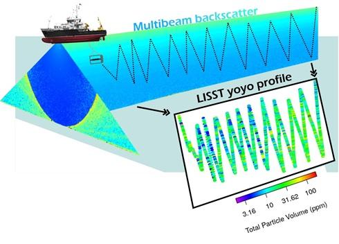
This summer 2020, we successfully tested a novel set-up on the RV Simon Stevin to semi-synchronously collect multibeam water column data and in-situ turbidity measurements. While the ship was slowly sailing, the LISST200X frame was towed in such a manner that it moved up- and downwards through the water column, hence defining a “yoyo” measurement path. This innovative multi-method approach will be further fine-tuned in future Timbers campaigns.
